


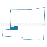
LIBERTY B Voting District, Knox County, Ohio
About
Outline

Summary
| Unique Area Identifier | 648205 |
| Name | LIBERTY B Voting District |
| County | Knox County |
| State | Ohio |
| Area (square miles) | 12.21 |
| Land Area (square miles) | 12.16 |
| Water Area (square miles) | 0.05 |
| % of Land Area | 99.59 |
| % of Water Area | 0.41 |
| Latitude of the Internal Point | 40.35852280 |
| Longtitude of the Internal Point | -82.59210890 |
Maps


Graphs
Select a template below for downloading or customizing gragh for LIBERTY B Voting District, Knox County, Ohio


Neighbors
Neighoring Voting District (by Name) Neighboring Voting District on the Map
- CLINTON B Voting District, Knox County, OH
- CLINTON C Voting District, Knox County, OH
- HILLIAR A Voting District, Knox County, OH
- LIBERTY A Voting District, Knox County, OH
- MILFORD A Voting District, Knox County, OH
- MILLER Voting District, Knox County, OH
- S BLOOMFIELD TWP E, Morrow County, OH
Top 10 Neighboring County Subdivision (by Population) Neighboring County Subdivision on the Map
- Hilliar township, Knox County, OH (3,715)
- Clinton township, Knox County, OH (2,826)
- Milford township, Knox County, OH (1,772)
- South Bloomfield township, Morrow County, OH (1,752)
- Liberty township, Knox County, OH (1,716)
- Miller township, Knox County, OH (1,006)
Top 10 Neighboring Unified School District (by Population) Neighboring Unified School District on the Map
- Mount Vernon City School District, OH (30,960)
- Highland Local School District, OH (10,233)
- Centerburg Local School District, OH (6,411)
Top 10 Neighboring State Legislative District Lower Chamber (by Population) Neighboring State Legislative District Lower Chamber on the Map
Top 10 Neighboring State Legislative District Upper Chamber (by Population) Neighboring State Legislative District Upper Chamber on the Map
Top 10 Neighboring 111th Congressional District (by Population) Neighboring 111th Congressional District on the Map
Top 10 Neighboring Census Tract (by Population) Neighboring Census Tract on the Map
- Census Tract 77, Knox County, OH (6,459)
- Census Tract 9655, Morrow County, OH (6,367)
- Census Tract 70, Knox County, OH (2,989)